
What we know about Category 5 storm Hurricane Beryl
- Hurricane Beryl strengthened into a Category 5 storm
- The storm has reportedly already killed two people
- As of Tuesday morning, storm is headed toward Jamaica
Testing on staging11
(NewsNation) — Hurricane Beryl barreled through the Caribbean Sea overnight into Tuesday as a Category 5 storm, making landfall in the islands of Grenada and now heading toward Jamaica and the Cayman Islands.
At least two people have died since the storm made landfall, and an emergency team was dispatched to Carriacou on Tuesday morning to assess the damage and provide essential aid to survivors.
Hurricane Beryl’s path of destruction
As the storm moved through the Caribbean Sea, rescue crews in the southeast Caribbean fanned out across the region to determine the extent of the damage that Hurricane Beryl inflicted after landing on Carriacou, an island in Grenada, as a Category 4 storm.
One person was reported killed in Grenada and another in St. Vincent and the Grenadines, officials said.
“The situation requires our immediate attention, and all efforts must be made to support our sister islands,” said Grenadian Prime Minister Dickon Mitchell.
A hurricane warning was in effect for Jamaica and a hurricane watch for Grand Cayman, Little Cayman and Cayman Brac. Beryl was forecast to start losing intensity on Tuesday but still to be near major hurricane strength when it passes near Jamaica on Wednesday, the Cayman Islands on Thursday and Mexico’s Yucatan Peninsula on Friday, according to the National Hurricane Center.
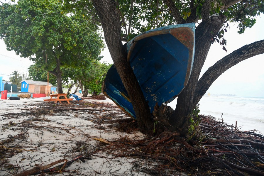
TOPSHOT – A boat ended up in a tree after the passage of Hurricane Beryl in Oistins gardens, Christ Church, Barbados on July 1, 2024. (Photo by Randy Brooks / AFP) (Photo by RANDY BROOKS/AFP via Getty Images) 
Damaged fishing boats pile up against each other after Hurricane Beryl at the Bridgetown Fish Market, Bridgetown, Barbados, July 1, 2024. (Photo by Randy Brooks / AFP) (Photo by RANDY BROOKS/AFP via Getty Images) 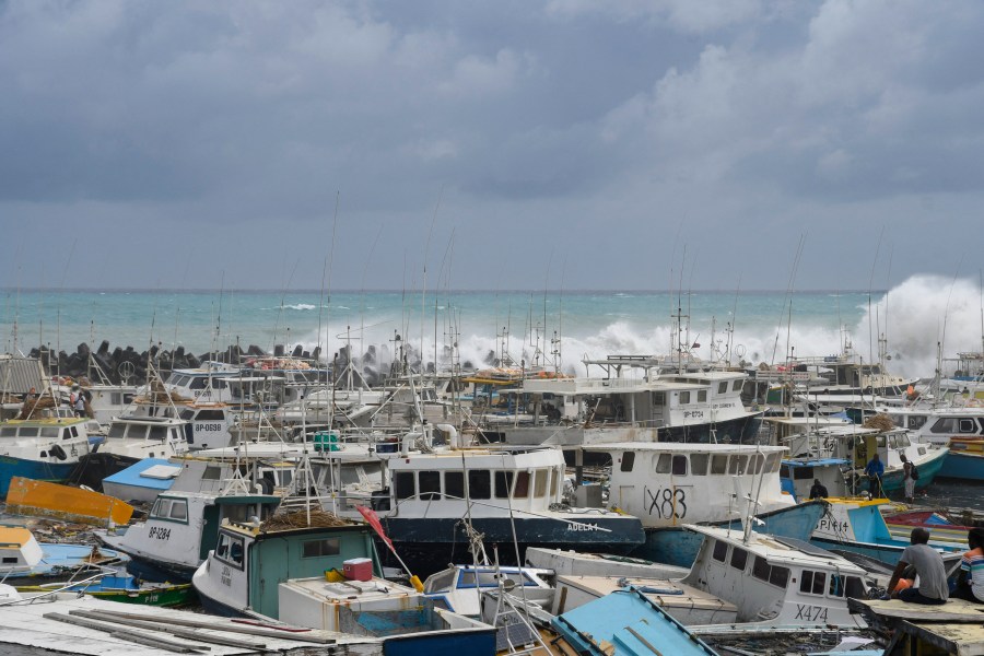
Damaged fishing boats pile up against each other after Hurricane Beryl at the Bridgetown Fish Market, Bridgetown, Barbados, July 1, 2024. (Photo by Randy Brooks / AFP) (Photo by RANDY BROOKS/AFP via Getty Images) 
View of a damaged restaurant on the beach near the Richard Haynes Boardwalk after the passage of Hurricane Beryl in Hastings, Christ Church, Barbados, on July 1, 2024. (Photo by Randy Brooks / AFP) (Photo by RANDY BROOKS/AFP via Getty Images) 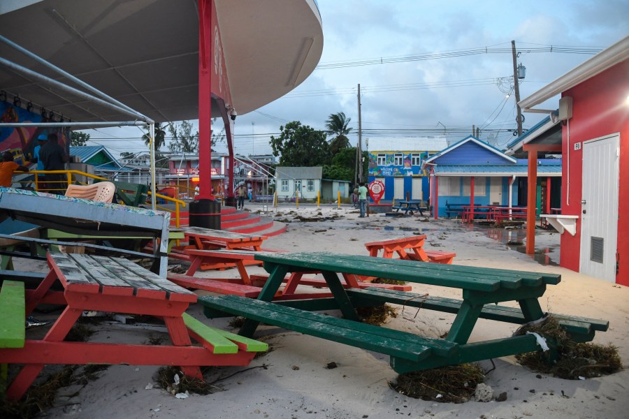
Damaged outdoor furniture is seen after the passage of Hurricane Beryl in Oistins gardens, Christ Church, Barbados on July 1, 2024. (Photo by Randy Brooks / AFP) (Photo by RANDY BROOKS/AFP via Getty Images) 
Houses damaged by Hurricane Beryl in Kingstown, Srt. Vincent and the Grenadines, Monday, July 1, 2024. (AP Photo/Lucanus Ollivierre) 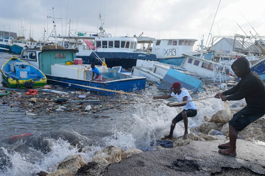
Fishermen pull a boat damaged by Hurricane Beryl back to the dock at the Bridgetown Fisheries in Barbados, Monday, July 1, 2024. (AP Photo/Ricardo Mazalan) 
Fishing vessels lie damaged after Hurricane Beryl passed through the Bridgetown Fisheries in Barbados, Monday, July 1, 2024. (AP Photo/Ricardo Mazalan) 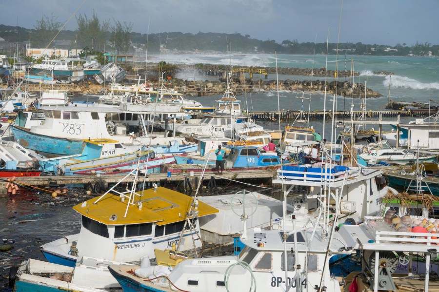
A fisherman looks at fishing vessels damaged by Hurricane Beryl at the Bridgetown Fisheries in Barbados, Monday, July 1, 2024. (AP Photo/Ricardo Mazalan) 
A fisherman looks at fishing vessels damaged by Hurricane Beryl at the Bridgetown Fisheries in Barbados, Monday, July 1, 2024. (AP Photo/Ricardo Mazalan) 
Fishing vessels damaged by Hurricane Beryl sit upended at the Bridgetown Fisheries in Barbados, Monday, July 1, 2024. (AP Photo/Ricardo Mazalan) 
Sylvia Small, right, waits for police approval to enter the pier to check her boat’s damages due to Hurricane Beryl at the Bridgetown Fisheries in Barbados, Monday, July 1, 2024. (AP Photo/Ricardo Mazalan) 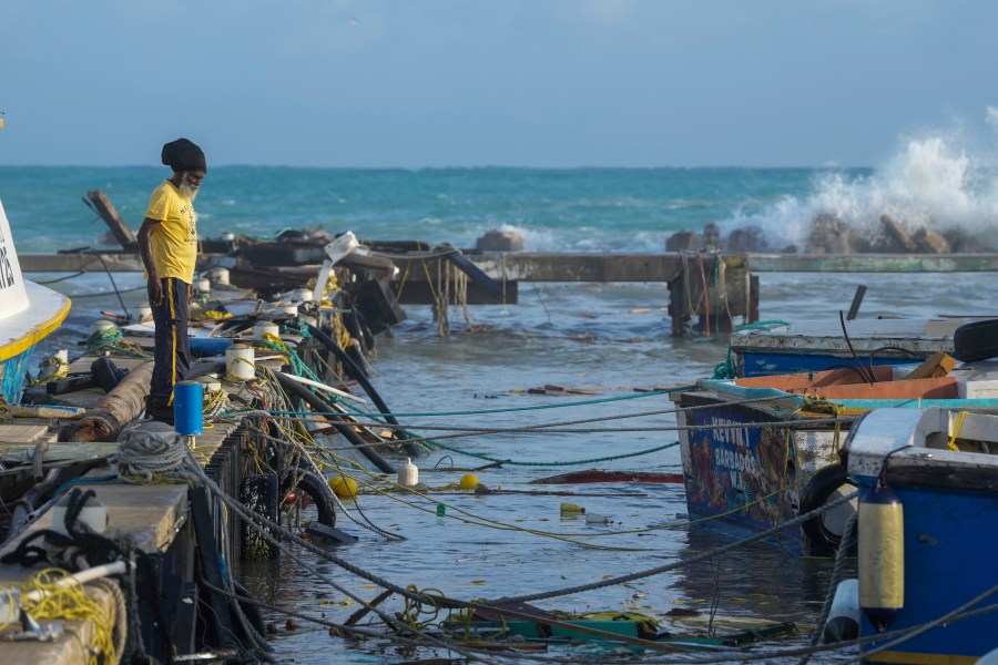
A fisherman looks out at vessels damaged by Hurricane Beryl at the Bridgetown Fisheries in Barbados, Monday, July 1, 2024. (AP Photo/Ricardo Mazalan) 
Fisherman Hamilton Cosmos looks at vessels damaged by Hurricane Beryl at the Bridgetown Fisheries in Barbados, Monday, July 1, 2024. (AP Photo/Ricardo Mazalan) 
A tree lies on the roof of a house in Kingstown, St. Vincent and the Grenadines, after Hurricane Beryl on Monday, July 1, 2024. (AP Photo/Lucanus Ollivierre)
A tropical storm warning was also in place for the entire southern coast of Hispaniola, an island shared by Haiti and the Dominican Republic.
“Beryl remains an impressive Category 5 hurricane,” the National Hurricane Center said.
While the storm is projected to downgrade before making landfall over Jamaica, the country will still likely receive high-end impacts of heavy rain and high winds.
Mexico’s Yucatan Peninsula is likely to be hit Friday, but there is a question of how strong the storm will be and what happens after.
How powerful is Hurricane Beryl?
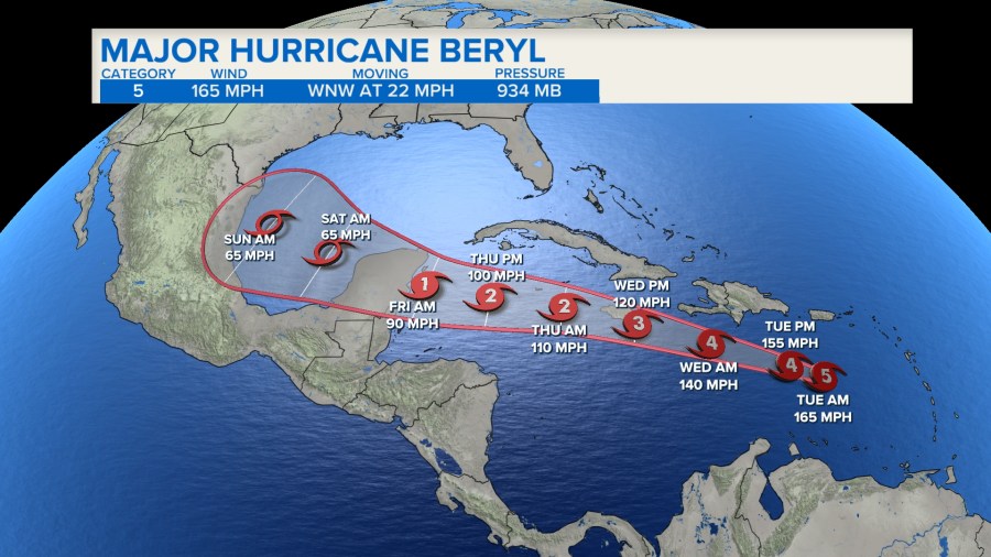
The storm reached Category 5 strength late Monday and intensified further early Tuesday morning to 165 mph winds.
The hurricane amassed its strength from record-warm waters that are hotter now than they would be at the peak of hurricane season in September, said hurricane specialist and storm surge expert Michael Lowry.
The National Oceanic and Atmospheric Administration predicted the 2024 hurricane season was likely to be well above average, with between 17 and 25 named storms. The forecast called for as many as 13 hurricanes and four major hurricanes.
An average Atlantic hurricane season produces 14 named storms, seven of them hurricanes and three major hurricanes.
What makes Hurricane Beryl noteworthy?
According to Philip Klotzbach, a Colorado State University hurricane researcher, Beryl has broken several records, including marking the farthest east that a hurricane has formed in the tropical Atlantic in June.
Beryl is the earliest Category 5 storm ever to form in the Atlantic.
It also was the earliest Category 4 Atlantic hurricane, besting Hurricane Dennis, which became a Category 4 storm on July 8, 2005.
Plus, the hurricane strengthened from a tropical depression to a major hurricane in just 42 hours, which only six other Atlantic hurricanes have done, with Sept. 1 as the previous earliest date, according to hurricane expert Sam Lillo.
The last strong hurricane to hit the southeast Caribbean was Hurricane Ivan 20 years ago, which killed dozens of people in Grenada.
Beryl is the second named storm in the Atlantic hurricane season, which runs from June 1 to Nov. 30. Earlier this month, Tropical Storm Alberto made landfall in northeast Mexico and killed four people.
Will Hurricane Beryl reach the US?
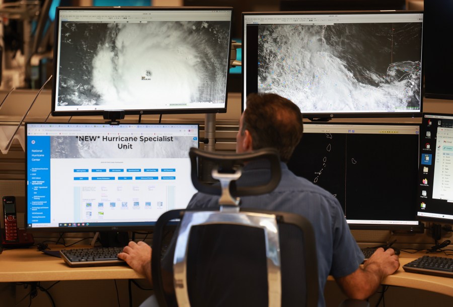
MIAMI, FLORIDA – JULY 01: John Cangialosi, Senior Hurricane Specialist at the National Hurricane Center, works on tracking Hurricane Beryl, the first hurricane of the 2024 season, at the National Hurricane Center on July 01, 2024 in Miami, Florida. On Monday afternoon, the storm, centered 30 miles west-northwest of Carriacou Island, became the strongest hurricane this early in the season in this area of the Atlantic. (Photo by Joe Raedle/Getty Images) 
MIAMI, FLORIDA – JULY 01: Brad Reinhart, Senior Hurricane Specialist at the National Hurricane Center, works on tracking Hurricane Beryl, the first hurricane of the 2024 season, at the National Hurricane Center on July 01, 2024 in Miami, Florida. On Monday afternoon, the storm, centered 30 miles west-northwest of Carriacou Island, became the strongest hurricane this early in the season in this area of the Atlantic. (Photo by Joe Raedle/Getty Images) 
This National Oceanic and Atmospheric Administration satellite image taken at 10:50pm EDT shows hurricane Beryl, center, as it moves across the Caribbean on Monday, July 1, 2024. Hurricane Beryl has strengthened to Category 5 status as it crossed islands in the southeastern Caribbean. (NOAA via AP)
While there’s always a chance the storm could turn north, it’s highly unlikely Hurricane Beryl will hit the United States. The forecasted path for Beryl has it projected to make landfall in Mexico’s Yucatan Peninsula on Friday morning.
The latest computer model updates from Tuesday morning showed a slight shift north with potential tracks, meaning areas in the western Gulf of Mexico, including Texas and even possibly Louisiana, could see some effects.
Those states will need to monitor the storm for any possible impacts early next week.
The Associated Press and NewsNation’s Max Tsaparis contributed to this report.